In a return to schedule, welcome to the second post in my series exploring different mapping softwares. In the first post, I explored Family Tree Maker and what its mapping feature had to offer. This time, I am going to get straight down to business and talk about the other two software-based programs that I have looked at. Remember that I am looking at these from a genealogist’s perspective and am particularly interested in their copyright specifications; especially on sharing their maps with clients.
Family Atlas
First up today, is Family Atlas from RootsMagic. Now, I haven’t personally used RootsMagic, but I know others who use it as their go-to tree-creating software. I was therefore interested to see how Family Atlas shapes up.
Family Atlas can easily be found on the RootsMagic website, where there is a useful information section. The program can be used on both Windows and Mac, although apparently the Catalina (10.15) Mac operating system does not support it yet. Not being a Mac user, I have no idea what that means, but I am sure it is important for Mac users to know!
Price-wise, Family Atlas comes in at $29.95. The exchange rate on the day I bought it, made this about £22. In comparison to Family Tree Maker (currently £79.95), that is not bad at all! You do have to remember though, that FTM is aiming to be a complete package and Family Atlas is only for mapping. At the time of writing, it is possible to buy both RootsMagic and Family Atlas as a package (currently $49.90), but this is not available for download only. You would need to buy this as a CD and download. Still, if you are looking for family tree software and you like the look of RootsMagic, this is not a bad option. The download was also painless and went smoothly, so I was very relieved!
Importing your data
To start using the program, you need to import either genealogical data or place data. I chose to ‘import and plot my genealogy’ and used the inbuilt wizard to help me. This was all very easy and the wizard walked me through step by step, but it did not want to read my FTM file. That was not too big a deal though, as I just exported my FTM tree to a GEDCOM file- no problem. It is also supposed to read files from RootsMagic, Legacy and PAF 5. This is something I would advise you to remember if you ever chose this particular software. I would make sure you can transfer your family tree into a GEDCOM file if necessary.
The wizard lets you select any of these file types and then browse your computer for the file you want. It then geocodes all of the place data and lets you choose whether to choose out of its suggestions for places it couldn’t find. Exactly like FTM, this includes Paul Gouly de Chaville’s birthplace, Viroflay. At this point, I began to wonder if my data wasn’t quite right, but the best match seems to use the modern place name instead: Viroflay, Isles-de-France, France. A better match than FTM, but for me, it doesn’t quite capture the historical data. Perhaps a general problem when trying to map historic names using modern software! In any case, you don’t have to accept this step, although it does affect the plotting of these locations. Basically, they aren’t plotted.
The Map pane for Family Atlas, showing the vital events for Edward James GOULY. Map is copyright of RootsMagic.
Adding more information
The next step is to add ‘genealogy markers,’ which are the points you want to plot. This is also relatively straightforward. You can give them a title, change the size, colour and style of both the marker point and the accompanying text and (like FTM), you can join them all up with a line on the map. There is also a rather nifty time slider option which allows you to choose to view events in a specific time scale. A drawback is that only county names are viewed in addition to the points plotted. Even zooming in does not show any nearby cities or towns, if you wanted to orient yourself within a county. The map publishing function does not show the lines joining the various events, but you can add a title and a legend. There is also the facility to add text boxes and lines yourself. It works a little like Word and Publisher in that respect.
Printing and sharing
I will need a little more time to play with all the features, but the edited map can be printed or exported to JPG or PDF files. What I am concerned with, is any rules governing the printing and sharing of the map. Many of you may not be surprised, but after minutes of searching, I could not find any specific references to sharing rules at all! I searched the RootsMagic website and the Family Atlas Program and all I came up with is:
If any other users of Family Atlas are reading this, then I would be happy to know if I have missed something here. But, this is a completely non-specific statement which doesn’t help me at all. I think an email to RootsMagic is needed, as you could infer that everything you do using Family Atlas is copyright of RootsMagic. In a way, I am a little surprised that this copyright statement is not more specific, as this is a program tailored to genealogy. I might expect a company such as Bing (used in FTM) to be a bit vague and not specifically mention genealogists. They are, after all, aiming at a broader market. But for RootsMagic to exclude a clause supporting or prohibiting use for professional genealogists who may wish to pass maps on to their clients? That is more unexpected. Although, I suppose it shows that the target market would be those researching for themselves without payment changing hands. I will be interested to see what RootsMagic say.
Map My Family Tree
Onwards to Map My Family Tree then. This is a standalone program produced by Progeny Genealogy, which I found through S & N Genealogy. It is currently selling for £24.95 (download only) from S & N Genealogy or $34.95 (download) and $39.95 (CD, US only) from Progeny Genealogy’s website.
Importing your data
I had a few difficulties downloading this from S & N (although that may have had more to do with general website issues at the time). Again, I had trouble opening my FTM file and had to use a GEDCOM file instead- FTM files after 2008 are not supported. Perhaps users of other programs will have more luck. MMFT is supposed to support additional files from:
Ancestral Quest (version 12 or later)
Family Historian
Legacy Family Tree
Personal Ancestral File
RootsMagic (ver. 3)
The Master Genealogist
As with Family Atlas and FTM, there are issues with the distinction of historic and modern place names which subsequently don’t get plotted. But the importing of your files is simple and just uses the ‘open’ function as you would in other programs like Word. You then just find the file and the program does its thing and encodes the place names and information.
Like the other programs I have explored so far, MMFT gives you options to change the colour of the map, the colour and font of the text; the latter down to the town, title, person and legend. The zoom function and movement of the map is straightforward enough, but some features are a little slow in loading. There is the option to focus in on events in a particular country or view them on the world map. On the face of it, the program is simple and perhaps too much so, if all you get is a list of places and events, plotted on a map. You do have a bottom pane below the map which lists the people in the tree, but to get more out of the program you have to actually read the instructions! As I have mentioned, I am not always great at reading the instructions and I prefer a more intuitive program in which I refer to the instructions if I have a problem.
The Map pane for Family Map My Family Tree, showing the vital events for Edward James GOULY and sister Emma. Map is copyright of Progeny Genealogy.
Adding more information
The program uses filters to show events relating to specific people and you create a filter using their specific dates, gender, number of generations or events. An advantage this has over other programs so far, is the ability to easily show more than one person at a time. I can see the events for Edward James Gouly de CHAVILLE, as well as those for his sister Emma. You do have to activate the filters though, or else you simply see the plots for all of the places in the family tree.
I haven’t yet mentioned the Gazetteer function, even though it is similar in nature to those from other programs. There is the ability to search for place names, create an ‘ignore’ list and set specific abbreviations for place names of your choosing. What it does have that the others do not, is a direct link through to Google Earth Pro. I already had Google Earth Pro for the next set of reviews, so I will talk more about that next time, but this does open up a completely different way of mapping to the rest of MMFT. It also brings up copyright issues, which I will come to in a moment. There are various other links to other similar programs (such as MapQuest or Google Maps), if you already have access to those programs.
Printing and sharing
The printing function is very simple indeed and is just that. There is no editing of the print ready map as with Family Atlas. You can however, publish the map as a PDF or JPG file, although (from the time I have spent with it) there seems to be no point. Viewing further information about the event in relation to the place seems impossible, unless you have a big long title on your map. This is at least an option when you edit the map in Family Atlas. This is more personal preference as to how it looks though.
As with Family Atlas, I could find no specific copyright statement that would tell me whether I could share maps with clients without infringing that copyright. There was nothing either within MMFT itself or on the Progeny website. Yet again, I can see an email to Progeny in my future to ask! Google Earth Pro would be a different matter though as, like Bing, Google has its own copyright statements which I would need to explore should I use that function through MMFT. As Google Earth Pro is part of my next post, I will come to their copyright statements next time.
Some concluding thoughts
On the whole, out of the two programs in this post, I prefer Family Atlas. MMFT seems a bit too simple on the face of it and does not do what I had hoped. Although, I do think that I would need more time to really read the manual in-depth, as there is probably much more to it that at first glance. In terms of being user-friendly, it just seems a little clunky to me. Don’t just take my word for it though. I would definitely encourage you to have a look at other reviews concerning these programs so that you can make your mind up.
Next time, I will be looking at two popular online-based mapping programs and giving overall conclusions. So, I look forward to Google Earth Pro and Ordnance Survey!
Apologies for the slight break in my current series of posts about mapping software. If you haven’t seen the first one yet, you can find it here. I had to publish this post next, as it is quite time sensitive- any later and I would really miss the boat!
RootsTechConnect 2021
So, as I am sure you can work out from the title, this post will be about RootsTechConnect. I attended the show and both helped out with some of the exhibitors and had a look at some of the talks.
My first thought was how weird it all was! Having been to the last RootsTech in London in 2019 (getting on for two years ago, can you believe?), it definitely was different. Needs certainly must though this year, and in the absence of RootsTech being able to take place in person, RootsTechConnect was the solution.
To chat or not to chat?
As I am sure everyone will agree, it is much more fun to be able to meet up with fellow genealogists of all ages and stages of research. Meeting people (both new and old) is one of the reasons we travel the many miles to attend conferences like this. The team behind RootsTechConnect came up with the next best thing though, as the main mode of communication between attendees was the online chat function. I have never been a great user of online chat facilities, at least there are without a doubt those that use that sort of thing more than I do.
Whilst the online chat facility worked very well (i.e. I came across no break in service or such things), I am not sure how useful people really found it. Perhaps there were those who were chatting away, but I did not find that the case. Certainly, the chat facilities for the organisations I manned were very quiet indeed! This was true for both the Direct Messaging function, as well as the Chat Room function. The difference to a real time conversation is very obvious and I wonder if there is a better way. At least from the point of view of the organisations who took part. Instead of having to constantly man a chat function with no takers, perhaps some kind of real time video chat session would work? With each organisation having its own slot? In any case, it is something that I think would need some further thought for future online conferences.
What a range of presentations...!
Of course the best case scenario would be the ability to hold an in person conference at some point in the future. But I do think that there were benefits to holding something online. Firstly, there was the potential to connect with people from all over the world. An online conference automatically does away with the need to travel halfway across the world and improves accessibility. That is unless computer and internet access is a problem.
Unlike an in person conference, the keynote speeches were available at multiple times of the day (likely having been pre-recorded). So if you particularly wanted to hear the celebrity of the day talk about what family and genealogy means to them, just pick your time. This was also a benefit for all of the talks and lectures. There were those that were shown at a specific time, but there was also an almighty list of other pre-recorded talks that are accessible for a good long while yet. I use the word ‘almighty’ with good reason. The list of pre-recorded talks was 18 (yes, 18) pages long! I don’t know about you, but that was slightly intimidating!
As you might expect at the moment, the number of DNA talks was large. It is great to see so many people interested, although it is not always my thing. There was a great deal for the beginner, for specific countries and areas, for certain record types and that is only the tip of the iceberg. Summarising 18 pages worth in a few sentences is not going to happen successfully, so I will have to just say that the choice was huge. Being a worldwide conference, I could see that the organisers were trying to cater to a huge range of interests. No obvious Medieval subjects though, but that’s just me…
...but was that a problem?
There is a problem with the range of talks that were available. As I said before, I found it intimidating and perhaps there were slightly too many. There were certainly many more than would be available at an in person conference, and choosing between ones available usually are difficult enough! I also felt the search function on the RootsTechConnect website was not as helpful as it could be. Perhaps it is just the researcher in me that would like to have seen an easier classification of the available talks. For instance, classifying by the language the talk is presented in is great, but I could see no further way of filtering. I still had to go through an endless scrolling process, making it almost essential to know the name of the talk to avoid that. However, if this is down to my lack of technical ability I will happily be corrected!
The talks I had a chance to view over the weekend were well presented and informative, although I would say that some were not automatically clear as to the country they related to. (Note to self: remember to read the description first!) There are still some that I would like to look at, so it is great that they will be around for some time to come. Having had a look (and been a part of) some of the exhibitor’s ‘stands,’ I thought the overall look was very professional and the allowance of different videos and uploads was helpful for both visitors and exhibitors. From a purely British perspective, I did feel that some of the usual suspects were absent from the Expo Hall. But then, time and cost is something that no doubt would have played a part and would have been considered within each organisation. Being the maiden voyage of RootsTechConnect, there are no doubt those who would have been unsure as to the benefit and reach. It was interesting to see exhibitors from abroad, who I might never get to see normally. Another benefit of an online conference.
In conclusion...
There are certainly pros and cons here and some issues that could be revisited. But on the whole, at a time when we are not able to do this in person, RootsTechConnect did the next best thing. Who knows, perhaps there might be space in future for both the in person RootsTech conference and some kind of online event? No doubt the intricacies of both will need to be worked out within the current state of things. We will have to wait and see, but until then I hope to eventually see you all again, hopefully in person!
Welcome to this week’s blog post. This will be the first in a series about my search for good mapping software. As you might have noticed, maps are a bit of a theme in my writing at the moment! There are no doubt other posts which give an overview of the pros and cons of all sorts of programs. In this series, I also wanted to explore the options in terms of copyright limitations as well.
The search begins...
For a long time now, I have been interested in finding a good way of mapping various places associated with my ancestors using computer software. Whether that is where they were born, died or where they lived in the census years. There are many times in our ancestor’s lives where we may want to plot their address, no matter if they have stayed in the same place for most of their lives, or if they moved elsewhere. A map of these locations can be helpful as a visual aid and as a collection of the information we have.
There are many different programs available to help with this, so I wanted to discover which one would be most useful for me by taking a look at a few. This is by no means a comprehensive list and personal preference does come into the decisions I have made, so do consider these and any others that you find yourselves too.
What and Why?
To begin then, which programs have I looked at? Firstly, as I already happen to have Family Tree Maker, I have explored their in built mapping function. I have looked at two other software based programs: Family Atlas from RootsMagic and Map My Family Tree. I also looked at two web based programs: Google Earth Pro and the Ordnance Survey online facility. Today's post will explore Family Tree Maker.
You can imagine that accurate mapping and an ability to input multiple locations on different maps would be of use. Price would also be a factor, but as a genealogist, the ability to share maps with others is also important. This brings me to the issue of copyright. As I also undertake client work, how do these programs set out their copyright clauses? Would I be able to edit a map with the information of a client’s ancestors and include that in a report? Let us find out!
Family Tree Maker
Family Tree Maker is not for everyone. It so happens to be the software I use for creating family trees, but it is certainly not the only one- I have just got used to using FTM over the years. As such, it is perhaps a little expensive in comparison to other programs. The current price (at time of writing) is £79.95 and the main purpose is not really for mapping. That is just a part of the program. Maybe it is not one for those specifically looking for mapping software, who do not already own FTM. After all, the clue is in the name- Family Tree Maker!
FTM map view, sorted by person. The vital events plotted are those for Edward James Gouly (c.1827-1916). Map is copyright of Microsoft (Bing Maps) and FTM copyright of McKiev.
What are the features?
Having said that, if you do own it or are considering it, the mapping facility is not bad. It uses Bing maps, so an internet connection is essential. It works off the places you enter for each person in any specific family tree and there are two ways of viewing them:
By place- this is an alphabetical list of all places associated with people in the family tree. Clicking on a place will then show you who it is associated with and you can expand the person to show the event it is connected to.
By person- this is again an alphabetical list, but of each person in the family tree. You can then check the boxes of the facts you would like to see on the map and then each checked box shows the place associated with that fact.
An advantage of the second option, is that each plotted place is connected with a line. This means you can easily see where an ancestor was located at various points in their life. I personally prefer this view as it fulfils more of what I want when it comes to mapping my ancestor’s lives. A downside though, is that the points plotted only show which event it relates to when you click on it. The details come up in another window and basic details automatically shown on the map itself.
Other useful points
There are different map views, including a Road map, Aerial and Birdseye views, as well as Streetside and Ordnance Survey options. They include the facility to check unrecognised place names in order to resolve errors and misspellings, although I have not yet found that helpful for the particular tree I used. This tree belonged to some research I am currently undertaking about a language teacher named Paul Benoit Joseph Gouly de Chaville. He was briefly mentioned in my previous post about the history of my own house. Paul was French and born in Viroflay, in what would have been Yvelines, Seine et Oise. FTM doesn’t recognise this and suggests ‘Oise, Picardie, France.’ This doesn’t capture all of the information I would include for Paul’s birthplace. Of course, the program will only be as good as its code and this will dictate how well it recognises more unusual and/or historical names. You can also create migration maps for families, but that is something for another time. I am notoriously terrible at reading the manual, so I highly recommended that you do! The manual will tell you all of the things that the program can do, which I cannot go into here.
Copyright issues
One of the most important things for me, is of course the ability to share maps. FTM does allow you to print maps and share a place usage report (essentially the list of places and the ancestors associated with them). For printing, it captures the specific image/page you are currently looking at. But what about the terms and conditions? They are a bit of a maze, as they also have to take into account terms and conditions from other providers (yes Bing itself uses other providers and links to their Ts&Cs!). Unfortunately, they do not leave me feeling any clearer as to whether I could use their maps in client reports.
The Print Rights section seems to allude to the permissible use of sending PDF prints to customers, under the commercial purposes clause. For some reason, this is specifically for the Microsoft® Bing™ Maps Platform API.[1] On the other hand, the Microsoft Bing Maps and MapPoint Web Service End User Terms of Use, declares,
"Bing Maps and MapPoint Web Service is for your individual use, solely for internal use by you for your business, or for your own personal use. You may not modify, copy, distribute, transmit, display, perform, reproduce, publish, license, create derivative works from, sublicense, transfer, assign, rent, sell or otherwise convey any information, software, products or services obtained from Bing Maps and MapPoint Web Service without the prior written consent from Microsoft."[2]
This certainly suggests that I could not reproduce anything in a client report without written permission. Bing Maps is obviously not going to be written with genealogists in mind. I would want some further clarification from them before I used any of their maps in a client report- even through FTM.
Conclusions?
The conclusion I have reached is partly inconclusive! The mapping facility is OK and is easy enough to use. It seems to do most of what I would like, but it has a few drawbacks in that a printed map just shows plotted points. There is no indication of what they relate to. Not ideal. Then there is the copyright situation, which I would definitely need to clarify before I use the maps in client work. If any readers have experience with using Bing Maps for client work, I would be happy to hear about it!
Onwards to the next post then, which explores Family Atlas from RootsMagic and Map My Family Tree. Will they be more suitable? Will they be any clearer in terms of copyright? Join me next time to find out!
Welcome to my first post of 2021. It is just a short(er) one to ease into the new year. I have some other posts planned, which I am very excited about! Keep on the lookout for those throughout the year! In the meantime, check out my previous posts.
YouTube and Genealogy
For today’s post then, I thought I would talk a little bit about YouTube and one particular video that I found highly interesting. Contrary to what you may think, I don’t actually have a YouTube channel, either for genealogy or for personal use. I tend to only use Twitter for Genealogy related business too. So, you can see that I am not a heavy user of social media.
Imagine my surprise then, when I discovered the world of YouTube videos a few years ago! Unsurprisingly, I have been watching more since the Pandemic began. The sheer volume of ‘stuff’ you can get is mind blowing, but I had never really considered using them with genealogy in mind. I never thought that genealogy would really lend itself to a platform which consisted of videos. The very nature of research is not really something that can be illustrated like a musical performance or even a cooking demonstration.
What kind of videos are there?
How wrong I was! Merely typing in the search term ‘genealogy’ on YouTube returns a whole host of different videos. You can find explanatory videos from the big companies such as Ancestry, which take you through a ‘how to’ of different aspects of genealogy. You can find a company (Usefulcharts) which creates charts (including family trees), who take you through various historical (and sometimes not) family trees using their chart as a visual. There is also the common theme of ‘Top ten’ videos and things to avoid when researching your family tree. Other things that pop up are historical channels that have a few genealogical videos, DNA related videos and many more. The list goes on and I would be here for quite a while if I attempted to list them all.
When it comes down to it, the best way to deal with YouTube is perhaps in a similar way to other internet and social media platforms. It has a search box, so I need to think about my search terms. What you put in is what you get out (broadly speaking). There are bound to be many more videos that are useful and relevant to genealogists, no matter what your area is. You just have to pick your search terms.
An unexpected find...
That aside, whatever algorithm YouTube uses to suggest videos to you can also bring up some surprising results. Yes, some of them are not necessarily what I would be looking for, but some do pull you in. How these videos are chosen and the technical side of things is best addressed, both in a separate post and by someone more knowledgeable about these things than I am! Suffice to say that there is one particular video that popped up for me lately that I found immensely interesting.
There are those of us in the genealogical world that have (wait for it) no London ancestors or genealogical ties at all! I know, it is positively shocking! In all seriousness though, in my case my ancestors all come from the South West of England and Wales, with some added branches in Gloucestershire and Herefordshire. Most of them seemed fairly content to stay in those areas, as I have so far not come across any that made the trip to London. This means that I find understanding all things London, a bit trickier than those that live there and those who regularly find their ancestors making that journey.
This is where the specific video that popped up on YouTube comes in. It was called ‘Why does London have 32 boroughs’ and was made by Jay Foreman (who is also one half of the Map Men). As well as maps being a useful source for genealogists in general, this particular video aids in the understanding of London’s boroughs and how they ended up as they are today. As a non-Londoner, I found it a very clear explanation which certainly improved my understanding. Thought should also be given here, to the fact that some videos are sponsored and therefore have adverts within them (like the Jay Foreman videos). It is personal choice as to whether you are happy with this.
The video takes you through the history of the division of London and how the difficulties of past boroughs led to the current system. It would seem that even historically, the boroughs were not considered a satisfactory system (as they were) and so needed revision. The difficulties of this revision is also explored, along with the leftovers of the old system in London today. One of my favourite examples that the video uses is that St. Marylebone Crematorium is nowhere near the St. Marylebone of today!
...and a useful one!
I won’t go into great detail here of what the video contains. It would be better watched in my opinion! But, it does address certain issues that genealogists researching in London no doubt face. The difference of the pre-1965 boroughs compared to the post-1965 boroughs is certainly something you would need to be aware of. Knowing some history behind these and the changes would help any genealogist make decisions in their research. If a person disappears from one borough, what are the neighbouring ones for instance? Could they have travelled to a neighbouring borough or would they have travelled further afield? Were there specific boroughs they may have come from or gone to depending upon their religion, occupation, societal class and even nationality? London was after all, the home of many immigrants. And, what would the boundaries and names of these boroughs have been, depending upon the time period being looked at?
Essentially, you could see London as a mini country in itself. The type of research performed and information you might need could be similar to differentiating between different counties in England, Scotland, Wales, Ireland or any other country.
In conclusion...
At the end of the day though, this particular video certainly enhanced my understanding of the London borough system. I can now go to other sources for more information as well.
With that brief account in mind, I will leave you to explore YouTube for further genealogical videos that might be of use. You should still keep in mind the source of the video and the reliability of the information imparted, but it is certainly worth a look. You never know what you might find.
In my most recent blog post I spoke about Tithe maps in relation to the land on which my house is now built. You can find tithe maps at local archives and record offices, but more are becoming available online. If you have Welsh ancestors for instance, the National Library of Wales has an online collection of Welsh tithe maps. For England however, there is no central database. For most places, you would need to visit the local record office. They may have them digitised and available for access on computers in the centre. The Somerset Heritage Centre certainly does that. For more information, have a look at my previous blog post on Tithes.
Know Your Place- West of England
Luckily for those of us who have ancestors from the West of England, there is also a project called Know Your Place. This began as Know Your Place- Bristol in 2011, which aimed to digitise historic maps and other linked information. This was created in order to help people explore their geographical area. It is essentially a ‘digital heritage mapping resource.’[1] Tithe maps are included in the maps digitised, although you should check the coverage for your area before using them.
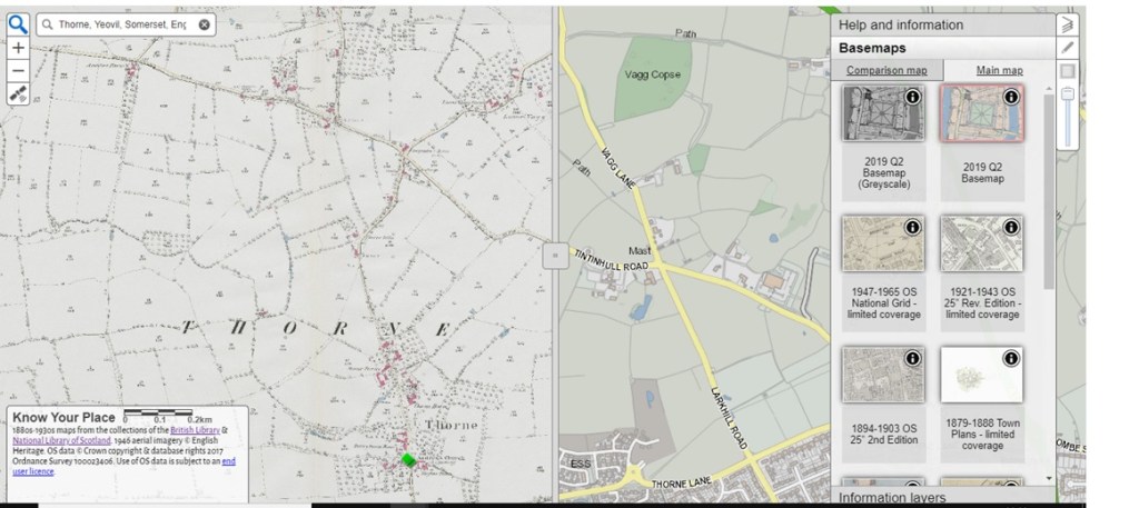
The coverage of the South West counties on Know Your Place has grown considerably since 2011. You can now find all sorts of resources from Gloucestershire, South Gloucestershire, Wiltshire, Somerset, North Somerset, Bath and North East Somerset and more recently, Devon. The home page allows you to click through to your county of interest and then you can use the search box to enter a specific place. I chose Preston Plucknett for my most recent blog post, but it is quite easy to choose the place you are interested in. It looks like these are based on modern places, with historical villages and places put into context of the modern place they were near to. For instance, there was a separate village to the north west of Yeovil, named Thorne or Thorne Coffin (not far from where I live). Nowadays, this village has been consumed by Yeovil, but you can still search for Thorne on the map. It comes up as ‘Thorne, Yeovil, Somerset, England, GBR.’ Other places with Thorne in the name also come up in a search. Street names such as ‘Thorne Lane’ or ‘Thorne Gardens’ and places outside of Yeovil, such as Thorney near Langport.
Maps galore!
When you have found your place of interest, what can you actually do with it? Well for starters, you can see a current map of your place as it looks today (a 2019 map is used). Always a helpful tool, you may say, but Google maps could show you that. The first standout point for Know Your Place is the screen divider which can be dragged from left to right across the screen. This allows you to have what the website calls a ‘main map’ and a ‘comparison map’ in the base map layer. The tool bar on the right hand side of the screen allows you to choose your main map and comparison map and you are not merely limited to a modern map compared with a historical map. Different historical maps can be compared, but pay attention when you choose your maps. Some do note that they have limited coverage.
So what maps can actually be compared? Know Your Place has various historical maps to choose from. When I searched for Thorne near Yeovil, the main maps that came up were as follows:
2019 Q2 Basemap (or the same but Greyscale);
1947-1965 Ordinance Survey map of the National Grid;
1921-1943 OS 25 inch Revised Edition;
1894-1903 OS 25 inch 2nd Edition;
1879-1888 Town Plans;
1844-1888 OS 25 inch 1st Edition;
1840s Tithe;
1840-pre Somerset Enclosures;
1849- post Somerset Enclosures;
1700s other.
These could also be used as the comparison map. I admit that I spent rather longer than expected comparing the maps and dragging the screen divider back and forth to see the changes in the landscape! As you might imagine though, the ‘1700s other’ map was the least useful, as the coverage was so sparse.
You could do all sorts of things using the main map and comparing it to other maps from different eras. The growth or decline of towns and villages can be explored, you could try to find out when your area or street was built (like I did) and you can get to know the geographical history of the place your ancestors lived. This does not have to be limited to one period in time either, as there are various OS maps from various years in time. Another important use of these maps is for anyone undertaking a One Place Study.
Information Layers
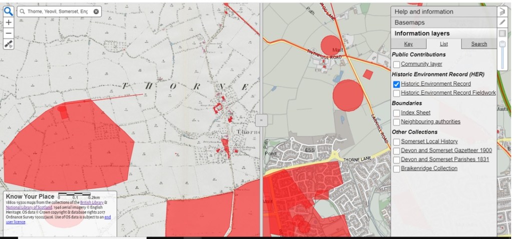
But these maps are just the tip of the iceberg. The website also uses what they call ‘Information Layers.’ These information layers add further information to the maps you have chosen, depending on which layer you choose. They are collated under the following headings:
Remember that these may be slightly different for different counties, but you can click on each heading for more information. Although at time of writing (December 2020) this facility does not seem to be working as it should.
What information do they contain?
As it suggests, the Community Layer contains contributions made by the people and organisations outside of those working on the Know Your Place project. This layer can contain pictures or paintings of places or even of monuments, people and coats of arms.
The Historic Environment Record layer is particularly useful, as it plots out the locations which have been researched on the map. These are not just Roman settlements and other ancient features, but could also be listed buildings or even WW2 defences and troop camps. For my own street, this layer shows the location of WW2 air raid shelters, emergency water tanks and roadblocks. These entries (for Somerset at least), then have links to external HER sites which in turn give you more information.
For Somerset, the Gazetteer and Parishes layers can show you where certain places from that specific gazetteer were located and also the parish boundaries. Again, very useful to be able to ‘see’ things which are only described elsewhere.
You can take these layers off or turn them on again by clicking the box next to them on the Information layers tab. This can be found in the toolbar on the right hand side of the screen, below the Basemaps tab. Again, have a look at what is available for the place you are looking for. There might be different layers to choose from.
Exploring the maps will certainly give you plenty to do, especially if you are at a loose end over the festive period. But the website still has more to offer. From the homepage, you can access other tabs which contain information about the project, a blog, a learning pack (aimed at Key Stages 2-4) and information about their online exhibition.
Caveats
There are a few caveats about using the website, chiefly the coverage of the maps offered need to be checked, both in terms of time period and geographical area. The other big issue is that this will only help those people with ancestors in or with a connection to the West of England. If you are hoping or planning to use images of the maps you find or any of the information included (for example, in paid research work or in a publishing capacity), do have a look at the ‘Copyright Guidance’ section. Most of the maps used are already being used on the website with the permission of a third party, so you may well have to contact that third party for any permissions you need. That being said, I would certainly recommended having a look at Know Your Place. Who knows, perhaps this could one day be expanded to other areas of the UK?
As this is also the last blog post of 2020, have a very Merry Christmas and let’s hope for a better year next year!
Welcome to the last post in my series about the history of my own house in Yeovil. So far, we have travelled back through time to the 1930s when a solicitor’s accountant (Barton Wey) lived in my house. Then we visited Albert Bollen who owned the land the house was later built on for a brief period in 1894, before his death a year later. A Yeovil man, he rose from a labouring background to becoming a solicitor himself. This time, we meet the men who were involved with the same land in the 1840s; the owner and the tenant.
Wonderful tithes...
The beginning of this story is not a baptism or birth, but a map. The 1848 Tithe Map for Preston Plucknett to be precise. Before Yeovil grew to its current size, there were many small villages on its western outskirts. Places like Thorn, Brympton, Lufton and of course Preston (or Preston Plucknett), were villages in their own right. Now of course, these villages are slowly being consumed by Yeovil as it expands ever closer to the larger villages of Odcombe and Montacute. This link to Google Maps will give you some idea of the area today.
Back in the 1840s however, Preston was its own separate village. Its history is too great to go into in this post, but local historian Bob Osborn has some excellent information here. The 1848 Tithe Map (found at KnowYourPlace-Somerset), shows that my house was in fact a field at that time. It was part of plot 137 and you can see the track that would later become Preston Grove. The accompanying apportionment[1] contains a wealth of detail. It tells us that the owner of plot 137 was one Robert Tucker and the occupier was one Joseph Roberts. The two men were also owner and occupier of plots 132-134, 136-139 and 141-148. Plot 135 was owned by Robert Tucker but occupied by one Gouly de Chaville. More about him another time!
These plots of land occupied by Joseph Roberts made up a total of 105 acres, 2 rods and 5 perches. Not a bad size and worth £5 5 shillings and 6 pence to the local vicar. For more information on how tithes worked, see my previous blog post on the subject. Altogether, this land was farming land and a part of Preston Lower Farm. The majority was pasture and meadow land, with plot 137 named as ‘Second Close’- this was also pasture. An additional aspect I would like to research in future is whether this was land for sheep or cattle.
So the tithe map has told us who owned and occupied the land, but what more is there to know? As you might imagine, the owner Robert Tucker was quite a well to do gentleman in Yeovil. Both he and his father (another Robert Tucker!) appear in the Somerset Electoral Register of 1832 for Yeovil Parish. They both lived in Hendford (another part of Yeovil) and both held a freehold house each, Robert senior in Milford and Robert junior in Hendford. This was what qualified them to be able to vote.[2] Robert senior died on 16 October 1841 (in Yeovil) at the age of 75. He was a ‘gentleman’ according to his death certificate.[3] Robert junior died 26 years later on 27 October 1867, at Hendford in Yeovil. He was 65 and a ‘landed proprietor.’[4] This certainly has airs and graces, but describes him quite accurately!
From what I have discovered, Robert junior was one of the many Yeovil glove manufacturers. He contributed to his community as Churchwarden, Town Commissioner and later Mayor of Yeovil (1858-1860). You can find this information and much, much more on Bob Osborn’s Yeovil website.
Joseph Roberts
But what about Joseph Roberts? There is certainly no handy biography of him to be found. But it turns out that Joseph was another man who elevated himself above his initial station in life.
Joseph was born to James and Jane Roberts in Marston Magna, Somerset. His baptism took place on 29 May 1806 in Marston.[5] Joseph’s obituary states that he began his business life at the ‘early’ age of 18 and was connected for many years with his brother-in-law George Hart. George was a well-known auctioneer and valuer in Yeovil and Martock.[6] The marriage of Joseph and George’s sister Mary took place on Christmas Eve of 1829 at Martock parish church. George was in fact, one of the witnesses.[7]
The move to Preston
A mere two years later in 1831, Joseph and wife Mary moved to Preston Plucknett and occupied Preston Lower Farm. According to the obituary, Joseph also farmed a large holding in Tisbury at the same time (on the Pyt House Estate).[8] This may explain why Joseph had moved from Preston to West Tisbury by the time of the 1861 Census. The rest of his family moved with him and they may have moved as early as 1855. Joseph was included in Kelly’s Directory for Wiltshire as being a farmer of West Tisbury for that year.[9]
Before the move though, Joseph and Mary farmed Preston Lower Farm for about twenty years, whilst their family steadily grew. From the various census records found,[10][11] Joseph and Mary had nine children during their time together: Jane, James, George, John, Francis, Joseph, William, Thomas, William and Mary Anna. Following up with all of these children is a project for another day!
By the time of the 1851 Census,[12] Joseph was employing seven labourers on Preston farm. After the move to Tisbury and Pythouse farm,[13] the size of Joseph’s farming land increased significantly to 440 acres. I am not surprised that Joseph needed to employ ten labourers and three boys to help him work the land! The most important piece of information on the 1861 Census though, is that Joseph is now calling himself a ‘landed proprietor’ as well. This certainly signals a rise in status, but the size of the farm also tells us that he had the funds for a holding that large. Even if it was rented, he must have had the means to pay that rent.
A rise in social status
But Joseph did not stop there. By the time of the 1871 Census,[14] not only had the family moved again, but Joseph was reporting a further change of occupation. The family were living at Jackley House in the village of Wyke, near Axminster in Devon (in Dorset at the time). From the looks of things, son William (to be determined which William!) was farming 200 acres and employing five men and two boys to help. His father Joseph was calling himself a ‘surveyor and landowner,’ which suggests that he had made the move from farming and renting land (as he had Preston Lower Farm from Robert Tucker) to owning land that others farmed.
This is borne out by various newspaper appearances that Joseph makes in his later years. In 1878, Joseph was named an umpire for a dispute over farming land,[15] a referee for a similar case in 1886[16] and a named evaluator of farming land in another similar case of 1887.[17] The latter article calls Joseph ‘a land surveyor of over 50 years’ experience.’ It is probably not surprising to learn that his obituary mentions that he valued land in 14 counties and a high value was placed upon his judgment in the matter of land surveying. Perhaps the early contact with his brother-in-law paved the way for Joseph in the world of land surveying.
From 1872, Joseph moved back to Preston where he apparently ‘carried on the business of an estate agent and auctioneer.’ His son William was involved too for a time. Joseph also founded the company Roberts, Son & Tory.[18] This company is certainly something that warrants further research. Sadly, Joseph’s wife Mary died on 09 March 1877 of bronchitis.[19] According to her death certificate, Mary was 73.
Mary's age is rather interesting though, as she died twenty years before her husband. Looking for a baptism of a Mary Hart in about 1804 in her birthplace of Martock, returns a curious result. The only baptism in the right place and at the right time was for a girl named Mary Hart who was aged 10 years old when she was baptised on 29 May 1805.[20] Her parents were Joseph and Sarah Hart and Mary was baptised with her siblings Ann (aged 16), Thomas (aged 13) and Avis. If this is correct, then Joseph’s wife Mary was a good ten years older than her husband and ten years older than every age she gave on every record found! This deserves some further research, but if correct, Mary must have looked amazing for her age!
For most of the rest of Joseph’s life, he lived in Preston Plucknett,[21][22] although not at Preston Lower Farm again. This time around, he could afford to live in a ‘private house’ (the exact address is not clear). He could also continue to pay to be included in the local directories. For both the 1889[23] and 1895[24] editions, he can be found under the list of private residents of Preston Plucknett. At some point before his death, Joseph moved back to Marston Magna, to live with his son William, at Marston Court. Joseph’s obituary records that he had apparently always wanted to end his life in the place it began. Joseph Roberts died at Marston Court on 28 March 1897 at the grand old age of 90.[25]
An impressive monument
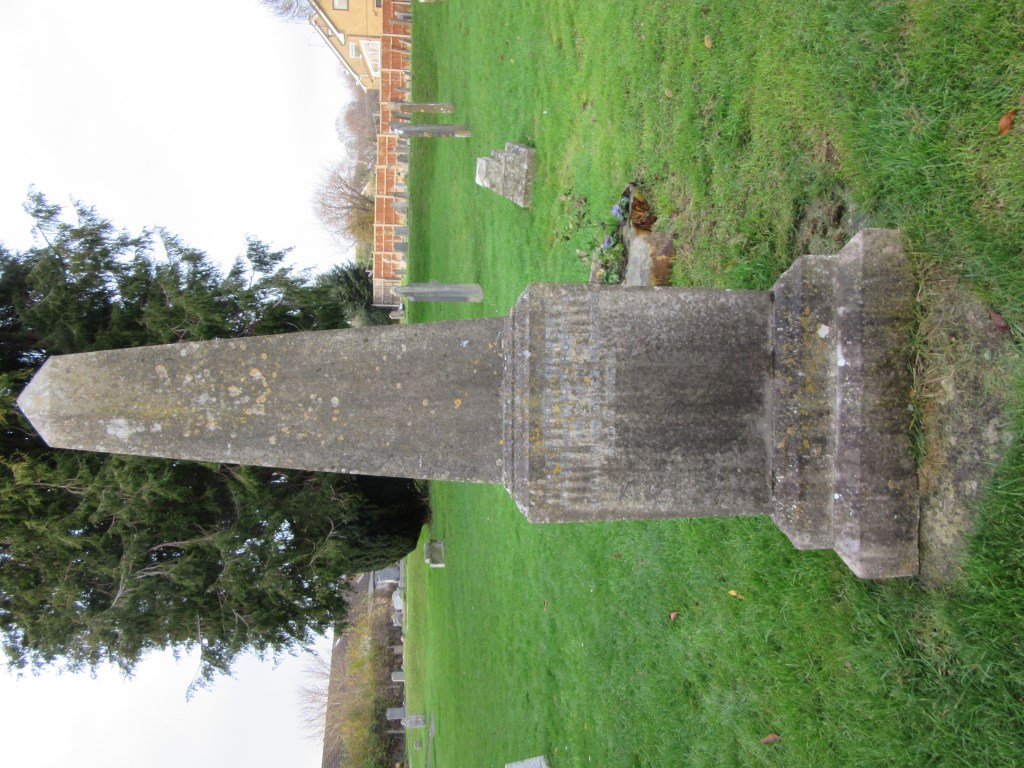
One further wonderful discovery made during the research for this post (of which there is much more to perform), is that Joseph was buried in St. James’ Church in Preston Plucknett and has a rather impressive obelisk shaped memorial![26] This memorial also marks his wife Mary (supposedly born on 14 April 1804), their son George and their grandson Harold (a son of William Roberts). If that is not a mark of elevated status, I do not know what is!
We have finally reached the end of the journey into the history of my house, at least as far as this blog is concerned. There are many more stories that did not make the final posts and much more to discover besides. I have thoroughly enjoyed discovering Barton Wey, Albert Bollen and Robert Tucker and Joseph Roberts. I hope you have enjoyed their stories as much as I have!
[1] Tithe apportionments. England. Preston Plucknett, Somerset. 1848. TUCKER, Robert (Owner) and ROBERTS, Joseph (Occupier). Plan number: 137. Collection: Diocese of Bath and Wells; Tithe Maps and appotionments; Tithe appotionments. D/D/rt/A/475. Somerset Heritage Centre, Taunton, Somerset, England.
[2] Electoral listings. England. Yeovil Parish, Stone Hundred, Somerset. 1832. TUCKER, Robert, the younger and TUCKER, Robert, the elder. Nos. 5498-5499. p. 120. In: Raymonds Electoral Registers (1996) The Somerset Electoral Register Western Division 1832. Exeter: S. A. & M. J. Raymond.
[5] Baptisms (PR) England. Marston Magna, Somerset. 29 May 1806. ROBERTS, Joseph. Collection: Somerset, England, Church of England Baptisms, Marriages, and Burials, 1531-1812. http://www.ancestry.co.uk : accessed 26 November 2020.
[6] Obituaries. (1897) Western Gazette.02 April. ROBERTS, Joseph. p. 6c. Collection: British Newspapers, 1710-1965. www.findmypast.co.uk : accessed 26 November 2020.
[7] Marriages (PR) England. Martock, Somerset. 29 May 1806. ROBERTS, Joseph. Collection: Somerset, England, Church of England Baptisms, Marriages, and Burials, 1531-1812. http://www.ancestry.co.uk : accessed 26 November 2020.
[8] Obituaries. (1897) Western Gazette.02 April. ROBERTS, Joseph. p. 6c. Collection: British Newspapers, 1710-1965. www.findmypast.co.uk : accessed 26 November 2020.
[9] Directories. England. (1855) Post Office Directory of Hampshire, Wiltshire & Dorsetshire. London: Kelly & Co. p. 119 [464]. Collection: UK, City and County Directories, 1766 – 1946. www.ancestry.co.uk : accessed 26 November 2020.
[10] Census records. England. Preston Plucknett, Somerset. 06 June 1841. ROBERTS, Joseph [head]. PN: HO107/958. FL 4. BN 7. ED 10. p. 2. http://www.ancestry.co.uk : accessed 26 November 2020.
[11] Census records. England. Preston [Plucknett], Somerset. 30 March 1851. ROBERTS, Joseph (head). PN: HO107/1930. FL 233. SN 61. ED 4. p. 14. http://www.ancestry.co.uk : accessed 26 November 2020.
[13] Census records. England. West Tisbury, Tisbury, Wiltshire. 07 April 1861. ROBERTS, Joseph (head). PN: RG9/1321. FL 58. SN 166. ED 3. p. 27. http://www.ancestry.co.uk : accessed 26 November 2020.
[14] Census records. England. Axminster, Dorset [Devon]. 02 April 1871. ROBERTS, Joseph (head). PN: RG10/2033. FL 37. SN 2. ED 2. p. 1. http://www.ancestry.co.uk : accessed 26 November 2020.
[15]Southern Times and Dorset County Herald. (1878) In the Court of the Queen’s Bench on Wednesday last…[Emas Shutler v. Alexander Osborne]. Southern Times and Dorset County Herald. 29 June. p. 5c. Collection: British Newspapers, 1710-1965. www.findmypast.co.uk : accessed 26 November 2020.
[16]Shepton Mallet Journal. (1886) Important case under the Agricultural Holdings Act. Shepton Mallet Journal. 16 July. p. 5d. Collection: British Newspapers, 1710-1965. www.findmypast.co.uk : accessed 26 November 2020.
[17]Western Times. (1887) A Farmer’s Appeal against Rates; Important decision. Western Times. 29 January. p. 3e. Collection: British Newspapers, 1710-1965. www.findmypast.co.uk : accessed 26 November 2020.
[18] Obituaries. (1897) Western Gazette.02 April. ROBERTS, Joseph. p. 6c. Collection: British Newspapers, 1710-1965. www.findmypast.co.uk : accessed 26 November 2020.
[20] Baptisms (PR) England. Martock, Somerset. 29 May 1805. HART, Mary. Collection: Somerset, England, Church of England Baptisms, Marriages, and Burials, 1531-1812. http://www.ancestry.co.uk : accessed 26 November 2020.
[21] Census records. England. Preston Plucknett, Somerset. 03 April 1881. ROBERTS, Joseph (head). PN: RG11/2393. FL 102. SN 13. ED 10. p. 17. http://www.ancestry.co.uk : accessed 26 November 2020.
[22] Census records. England. Preston Plucknett, Somerset. 05 April 1891. ROBERTS, Joseph (head). PN: RG12/1899. FL 114. SN 54. ED 11. p. 10. http://www.ancestry.co.uk : accessed 26 November 2020.
[23] Directories. England. (1889) Kelly’s Directory of Somersetshire. London: Kelly & Co. p. 314 [346]. Collection: UK, City and County Directories, 1766 – 1946. www.ancestry.co.uk : accessed 26 November 2020.
[24] Directories. England. (1895) Kelly’s Directory of Somersetshire, Gloucestershire and the City of Bristol. London: Kelly & Co. Limited. p. 352 [370]. Collection: UK, City and County Directories, 1766 – 1946. www.ancestry.co.uk : accessed 26 November 2020.
[26] Monumental Inscriptions. England. St. James’ Church, Preston Plucknett, Yeovil, Somerset. ROBERTS family. Transcribed by Rhiannon Lloyd, 29 November 2020.
Welcome to the next instalment of my series of blog posts about the history of my own house in Yeovil, Somerset. In the previous post I discovered more about the Wey family who lived in my house in the late 1930s and most of the 1940s. You may remember that the story of Barton Wey ended quite unhappily, but the records found show that Barton was well respected as an accountant. He worked for the Yeovil firm of solicitors Newman & Paynter and he was also involved with his community. This next instalment goes back in time even further- before Barton Wey bought my house. This is the story of Albert Bollen.
Humble beginnings
Albert Bollen was born on 13 January 1840 in Yeovil.[1] His parents were Thomas and Elizabeth Bollen (formerly Elizabeth Roscilly) and he also had a sister named Frances. Albert seems to have lived in Yeovil all his life, specifically in the Kingston area. From the census records available, it is often difficult to pinpoint exactly where Albert lived. But on the 1891 census, Albert is living at 13 Kingston.[2] This is next to Kingston House on the census, which later became part of the Park School.[3] This is the area of Yeovil near where the hospital is now located. Today, it is about a 20 minute walk from where my house now stands.
On the 1841 census,[4] both of Albert’s parents have recorded their occupations as servants. It is not really clear what their occupation was or who they worked for from this, but on Albert’s birth certificate Thomas states his occupation as a leather dresser. This was someone who dressed and finished leather hides after the tanning process.[5] Not a surprising occupation given the long history of the leather and gloving industries in Yeovil and the surrounding area. But by 1861 Albert’s father Thomas was a private lodging house keeper.[6] This is again in the Kingston area. From looking at some of the surrounding families in the census records for Albert, it is clear that Kingston was a mixed area. Some households were in the gloving trade, there were others who were tailors and yet others who were solicitors. Perhaps this last trade influenced Albert or perhaps solicitors in the area were looking for employees. By 1861, Albert had become a solicitor’s clerk and this was an area of work he pursued until his death in 1895.
A social climb
Before Albert’s marriage in 1867, there is evidence of him working as the local agent for an Assurance Society. In 1859 (aged only 19!), Albert was the Yeovil agent for the Wesleyan and General Assurance Society, whose head office was in Birmingham.[7] They placed an advert in the Sherborne Mercury, in which they were offering good rates for life and sickness assurance.[8] Albert was working out of the Emigration Office and was also the agent for the Cattle and Fire Insurance Offices too. Then, throughout 1861 and 1862 he acted in a similar capacity for the Indisputable Life Assurance Company of Scotland. The first reference found was an advert (again in the Sherborne Mercury) on 17 December 1861.[9]
Only a few years later in 1865, Albert appears in the newspapers again. This was only the beginning of many appearances in the local newspapers. In 1865 however, Albert was reported to have been first on the scene of an accident on the road between Sherborne and Yeovil.[10] I particularly enjoyed reading this article for all of the period references! Apparently Albert (now aged 25) and some companions had been to see a performance of ‘The Creation’ by Handel in Sherborne. This of course would have been very ‘high-brow’ and gives an indication of the sort of circles that Albert moved in [Note: this reference also appeals to my musician side, as I once played in a performance of ‘The Creation’ many years ago!]. To come from a family of humble origins (servants and leather workers), to being able to afford to see an opera was quite a social leap.
On the return journey from Sherborne, a horseman passed the opera-goers on the wrong side of the road, travelling at a furious speed. Albert remarked that they might have to ‘pick him up’ before too long and he was proven correct. They found the man (later named as Mr. Knott of Lyde Farm), lying in the road between Sherborne and Halfway House. Albert lifted the man into his own ‘conveyance’ and, on the advice of a Dr. Garland that the party met on the way to Sherborne, took the man home. The article finishes by saying that Mr. Knott was recovering. Sometimes when researching, I forget that Victorian travel was largely by horse and carriage (at least for those who could afford it). Articles like this really bring the era to life!
Sadness and sucess
The next stage in Albert’s life was likely a rollercoaster of emotions. He was married to Mary Anne Jessop on 29 August 1867, not in Yeovil, but in Radipole Church, in Dorset.[11] The couple did not have any children and a mere ten years later, Mary Anne sadly died. Her death was announced in the Taunton Courier and Western Advertiser on 10 October 1877. She had died on 30 September.[12] Albert never remarried, perhaps due to his grief or perhaps he never met another woman that he wanted to marry. We will likely never know his reasons.
Despite the sadness of his wife’s death, the decade after his marriage was also when his working career really took off. He made a fair number of appearances in the Western Gazette (a local Yeovil paper), as an executor or administrator involved with various probate cases. A notice from 1870 for those claiming debts against Richard Gale (deceased) is one such notice. Administration of Richard’s estate was granted to his brother Henry Gale of Ilminster and Albert Bollen of Yeovil on 19 October 1870.[13] In 1872, Albert makes the paper again, when the Western Gazette published a notice of his success in passing the preliminary examinations of the Incorporated Law Society that November.[14] A further notice was published in May 1876, stating that Albert had passed the final examination at the hall of the Incorporated Law Society in London. He was only waiting upon receipt of his certificate to practice as a Solicitor. This notice also says that Albert had been a clerk to Mr. W. Glyde.[15] William Glyde was one of various solicitors that practised in Victorian Yeovil,[16] although I do not yet know how long Albert worked for him.
Albert’s own premises were located at 75 South Street, Yeovil[17] and he was also included as a private resident, living at 13 Kingston in the 1889 Directory of Somerset.[18] His practice (according to the 1889 directory) was specifically as a ‘solicitor & commissioner to administer oaths in the Supreme court of judicature.’ There were various divisions of the Supreme Court of Judicature, which had been created between 1873-1875 after a reorganisation of the higher court system. It is not certain exactly what role Albert held from looking at the Directory entry, but it could be that he was involved with cases for the new Probate, Divorce and Admiralty division.[19] Many of his newspaper appearances are concerned with probate cases.
My connection to Albert
Albert lived at 13 Kingston until the end of his life, although on the 1891 Census, his sister Frances was also in the same household.[20] Albert had lived with Frances and her farmer husband George Wills for part of 1881, at Combe Farm, Crewkerne.[21] You may also be wondering how all of this relates to my house? The connection came late in Albert’s life, as the land which would later become my house was conveyed from George Willey Vincent and James Bernard Paynter to Albert Bollen on 31 December 1894.[22] This was a mere six months before Albert’s death on 10 June 1895 at his home of 13 Kingston in Yeovil. He was relatively young, aged only 55.[23] What happened to the land after Albert’s death is still a point that needs further investigation. From my last post, we know that by 1937, brothers Reginald Henry Ralph Lucas and Clifford Neatham William Thomas Lucas sold the house (as it had been built by then) to Barton William Henry Wey.
Whatever happened to the land after Albert’s death, my research into Albert and his life has discovered a man who rose up the ranks from working class leather workers, to the higher rank of solicitor. His personal life (perhaps like Barton Wey’s) may have been unfulfilled and tinged with sadness, but Albert’s career seems to have been very successful. He may not have been a part of any of the large 'solicitor dynasties' of Yeovil, but his story is still an impressive one.
Join me next time for the final post in this series. Going further back in time again, we meet a Mayor and a farmer.
[8]Sherborne Mercury. (1859) The Wesleyan and General Assurance Society. Sherborne Mercury. 19 April. p. 4c. Collection: British Newspapers. www.findmypast.co.uk : accessed 01 October 2020.
[9]Sherborne Mercury. (1861) Indisputable Life Assurance Company of Scotland. Sherborne Mercury. 17 December. p. 1d. Collection: British Newspapers. www.findmypast.co.uk : accessed 01 October 2020.
[10]Taunton Courier and Western Advertiser. (1865) Sherborne; Serious Accident. Taunton Courier and Western Advertiser. 27 December. p. 3b. Collection: British Newspapers. www.findmypast.co.uk : accessed 01 October 2020.
[11] Marriages (PR) England. Radipole, Dorset. 29 August 1867. BOLLEN, Albert and JESSOP, Mary Anne. Collection: Dorset, England, Church of England Marriages and Banns, 1813-1921. http://www.ancestry.co.uk : accessed 09 July 2020.
[12] Death announcements. England. 1877. Taunton Courier and Western Advertiser. 10 October. BOLLEN, Mrs. p.4e. Collection: British Newspapers. www.findmypast.co.uk : accessed 01 October 2020.
[13]Western Gazette. (1870) Re Richard Gale, Deceased. Western Gazette. 09 December. p. 4e. Collection: British Newspapers. www.findmypast.co.uk : accessed 01 October 2020.
[14]Western Gazette. (1872) Yeovil. Western Gazette. 29 November. p. 7b. Collection: British Newspapers. www.findmypast.co.uk : accessed 01 October 2020.
[15]Western Gazette. (1876) Miscellanceous District News; Yeovil; Success. Western Gazette. 12 May. p. 5d. Collection: British Newspapers. www.findmypast.co.uk : accessed 01 October 2020.