In my most recent blog post I spoke about Tithe maps in relation to the land on which my house is now built. You can find tithe maps at local archives and record offices, but more are becoming available online. If you have Welsh ancestors for instance, the National Library of Wales has an online collection of Welsh tithe maps. For England however, there is no central database. For most places, you would need to visit the local record office. They may have them digitised and available for access on computers in the centre. The Somerset Heritage Centre certainly does that. For more information, have a look at my previous blog post on Tithes.
Know Your Place- West of England
Luckily for those of us who have ancestors from the West of England, there is also a project called Know Your Place. This began as Know Your Place- Bristol in 2011, which aimed to digitise historic maps and other linked information. This was created in order to help people explore their geographical area. It is essentially a ‘digital heritage mapping resource.’[1] Tithe maps are included in the maps digitised, although you should check the coverage for your area before using them.
The coverage of the South West counties on Know Your Place has grown considerably since 2011. You can now find all sorts of resources from Gloucestershire, South Gloucestershire, Wiltshire, Somerset, North Somerset, Bath and North East Somerset and more recently, Devon. The home page allows you to click through to your county of interest and then you can use the search box to enter a specific place. I chose Preston Plucknett for my most recent blog post, but it is quite easy to choose the place you are interested in. It looks like these are based on modern places, with historical villages and places put into context of the modern place they were near to. For instance, there was a separate village to the north west of Yeovil, named Thorne or Thorne Coffin (not far from where I live). Nowadays, this village has been consumed by Yeovil, but you can still search for Thorne on the map. It comes up as ‘Thorne, Yeovil, Somerset, England, GBR.’ Other places with Thorne in the name also come up in a search. Street names such as ‘Thorne Lane’ or ‘Thorne Gardens’ and places outside of Yeovil, such as Thorney near Langport.
Maps galore!
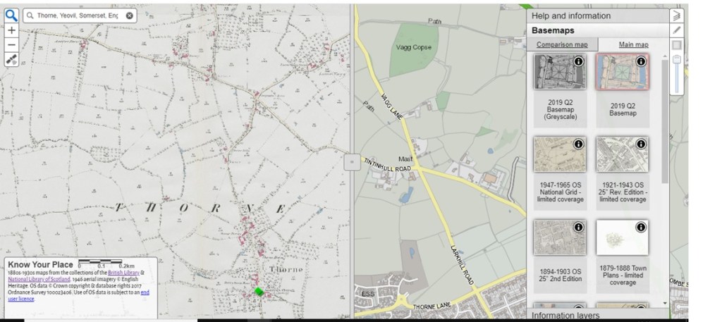
When you have found your place of interest, what can you actually do with it? Well for starters, you can see a current map of your place as it looks today (a 2019 map is used). Always a helpful tool, you may say, but Google maps could show you that. The first standout point for Know Your Place is the screen divider which can be dragged from left to right across the screen. This allows you to have what the website calls a ‘main map’ and a ‘comparison map’ in the base map layer. The tool bar on the right hand side of the screen allows you to choose your main map and comparison map and you are not merely limited to a modern map compared with a historical map. Different historical maps can be compared, but pay attention when you choose your maps. Some do note that they have limited coverage.
 |
| A view of the Know Your Place- Somerset map interface, showing the base map, comparison map, sliding divider and right hand tool bar. Courtesy of © Know Your Place- West of England. |
Which maps are included?
So what maps can actually be compared? Know Your Place has various historical maps to choose from. When I searched for Thorne near Yeovil, the main maps that came up were as follows:
- 2019 Q2 Basemap (or the same but Greyscale);
- 1947-1965 Ordinance Survey map of the National Grid;
- 1921-1943 OS 25 inch Revised Edition;
- 1894-1903 OS 25 inch 2nd Edition;
- 1879-1888 Town Plans;
- 1844-1888 OS 25 inch 1st Edition;
- 1840s Tithe;
- 1840-pre Somerset Enclosures;
- 1849- post Somerset Enclosures;
- 1700s other.
These could also be used as the comparison map. I admit that I spent rather longer than expected comparing the maps and dragging the screen divider back and forth to see the changes in the landscape! As you might imagine though, the ‘1700s other’ map was the least useful, as the coverage was so sparse.
You could do all sorts of things using the main map and comparing it to other maps from different eras. The growth or decline of towns and villages can be explored, you could try to find out when your area or street was built (like I did) and you can get to know the geographical history of the place your ancestors lived. This does not have to be limited to one period in time either, as there are various OS maps from various years in time. Another important use of these maps is for anyone undertaking a One Place Study.
Information Layers
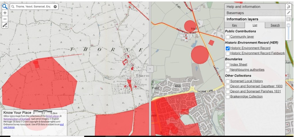
But these maps are just the tip of the iceberg. The website also uses what they call ‘Information Layers.’ These information layers add further information to the maps you have chosen, depending on which layer you choose. They are collated under the following headings:
- Public Contributions
- Community Layer
- Historic Environment Record (HER)
- Historic Environment Record
- Historic Environment Record Fieldwork
- Boundaries
- Index Sheet
- Neighbouring authorities
- Other Collections
- Somerset Local History
- Devon and Somerset Gazetteer 1900
- Devon and Somerset Parishes 1831
- Braikenridge Collection
 |
| A view of the Know Your Place- Somerset base map and comparison map, showing the Information Layers toolbar with the Historic Environment Record view. Courtesy of © Know Your Place- West of England. |
Remember that these may be slightly different for different counties, but you can click on each heading for more information. Although at time of writing (December 2020) this facility does not seem to be working as it should.
What information do they contain?
As it suggests, the Community Layer contains contributions made by the people and organisations outside of those working on the Know Your Place project. This layer can contain pictures or paintings of places or even of monuments, people and coats of arms.
The Historic Environment Record layer is particularly useful, as it plots out the locations which have been researched on the map. These are not just Roman settlements and other ancient features, but could also be listed buildings or even WW2 defences and troop camps. For my own street, this layer shows the location of WW2 air raid shelters, emergency water tanks and roadblocks. These entries (for Somerset at least), then have links to external HER sites which in turn give you more information.
For Somerset, the Gazetteer and Parishes layers can show you where certain places from that specific gazetteer were located and also the parish boundaries. Again, very useful to be able to ‘see’ things which are only described elsewhere.
You can take these layers off or turn them on again by clicking the box next to them on the Information layers tab. This can be found in the toolbar on the right hand side of the screen, below the Basemaps tab. Again, have a look at what is available for the place you are looking for. There might be different layers to choose from.
Exploring the maps will certainly give you plenty to do, especially if you are at a loose end over the festive period. But the website still has more to offer. From the homepage, you can access other tabs which contain information about the project, a blog, a learning pack (aimed at Key Stages 2-4) and information about their online exhibition.
Caveats
There are a few caveats about using the website, chiefly the coverage of the maps offered need to be checked, both in terms of time period and geographical area. The other big issue is that this will only help those people with ancestors in or with a connection to the West of England. If you are hoping or planning to use images of the maps you find or any of the information included (for example, in paid research work or in a publishing capacity), do have a look at the ‘Copyright Guidance’ section. Most of the maps used are already being used on the website with the permission of a third party, so you may well have to contact that third party for any permissions you need. That being said, I would certainly recommended having a look at Know Your Place. Who knows, perhaps this could one day be expanded to other areas of the UK?
As this is also the last blog post of 2020, have a very Merry Christmas and let’s hope for a better year next year!
© 2020 Shersca Genealogy.
[1] Know Your Place- West of England. About the Project. http://www.kypwest.org.uk/about-the-project/ : accessed 18 December 2020.
No comments:
Post a Comment