Monday, December 21, 2020

Know Your Place- a resource review

 In my most recent blog post I spoke about Tithe maps in relation to the land on which my house is now built. You can find tithe maps at local archives and record offices, but more are becoming available online. If you have Welsh ancestors for instance, the National Library of Wales has an online collection of Welsh tithe maps. For England however, there is no central database. For most places, you would need to visit the local record office. They may have them digitised and available for access on computers in the centre. The Somerset Heritage Centre certainly does that. For more information, have a look at my previous blog post on Tithes.

Know Your Place- West of England

Luckily for those of us who have ancestors from the West of England, there is also a project called Know Your Place. This began as Know Your Place- Bristol in 2011, which aimed to digitise historic maps and other linked information. This was created in order to help people explore their geographical area. It is essentially a ‘digital heritage mapping resource.’[1] Tithe maps are included in the maps digitised, although you should check the coverage for your area before using them.

The coverage of the South West counties on Know Your Place has grown considerably since 2011. You can now find all sorts of resources from Gloucestershire, South Gloucestershire, Wiltshire, Somerset, North Somerset, Bath and North East Somerset and more recently, Devon. The home page allows you to click through to your county of interest and then you can use the search box to enter a specific place. I chose Preston Plucknett for my most recent blog post, but it is quite easy to choose the place you are interested in. It looks like these are based on modern places, with historical villages and places put into context of the modern place they were near to. For instance, there was a separate village to the north west of Yeovil, named Thorne or Thorne Coffin (not far from where I live). Nowadays, this village has been consumed by Yeovil, but you can still search for Thorne on the map. It comes up as ‘Thorne, Yeovil, Somerset, England, GBR.’ Other places with Thorne in the name also come up in a search. Street names such as ‘Thorne Lane’ or ‘Thorne Gardens’ and places outside of Yeovil, such as Thorney near Langport.

Maps galore!

When you have found your place of interest, what can you actually do with it? Well for starters, you can see a current map of your place as it looks today (a 2019 map is used). Always a helpful tool, you may say, but Google maps could show you that. The first standout point for Know Your Place is the screen divider which can be dragged from left to right across the screen. This allows you to have what the website calls a ‘main map’ and a ‘comparison map’ in the base map layer. The tool bar on the right hand side of the screen allows you to choose your main map and comparison map and you are not merely limited to a modern map compared with a historical map. Different historical maps can be compared, but pay attention when you choose your maps. Some do note that they have limited coverage.
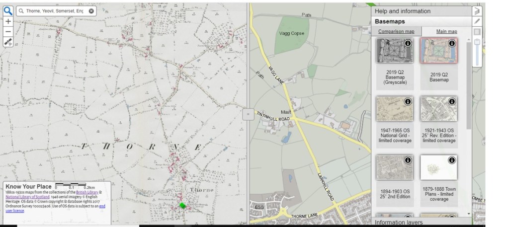
Know Your Place-a resource review_Shersca Genealogy_Map view of Thorne, Yeovil, Somerset_basic view
A view of the Know Your Place- Somerset map interface, showing the base map, comparison map, sliding divider and right hand tool bar. Courtesy of © Know Your Place- West of England.

Which maps are included?

So what maps can actually be compared? Know Your Place has various historical maps to choose from. When I searched for Thorne near Yeovil, the main maps that came up were as follows:

  • 2019 Q2 Basemap (or the same but Greyscale);
  • 1947-1965 Ordinance Survey map of the National Grid;
  • 1921-1943 OS 25 inch Revised Edition;
  • 1894-1903 OS 25 inch 2nd Edition;
  • 1879-1888 Town Plans;
  • 1844-1888 OS 25 inch 1st Edition;
  • 1840s Tithe;
  • 1840-pre Somerset Enclosures;
  • 1849- post Somerset Enclosures;
  • 1700s other.

These could also be used as the comparison map. I admit that I spent rather longer than expected comparing the maps and dragging the screen divider back and forth to see the changes in the landscape! As you might imagine though, the ‘1700s other’ map was the least useful, as the coverage was so sparse.

You could do all sorts of things using the main map and comparing it to other maps from different eras. The growth or decline of towns and villages can be explored, you could try to find out when your area or street was built (like I did) and you can get to know the geographical history of the place your ancestors lived. This does not have to be limited to one period in time either, as there are various OS maps from various years in time. Another important use of these maps is for anyone undertaking a One Place Study.

Information Layers

But these maps are just the tip of the iceberg. The website also uses what they call ‘Information Layers.’ These information layers add further information to the maps you have chosen, depending on which layer you choose. They are collated under the following headings:

  • Public Contributions
    • Community Layer
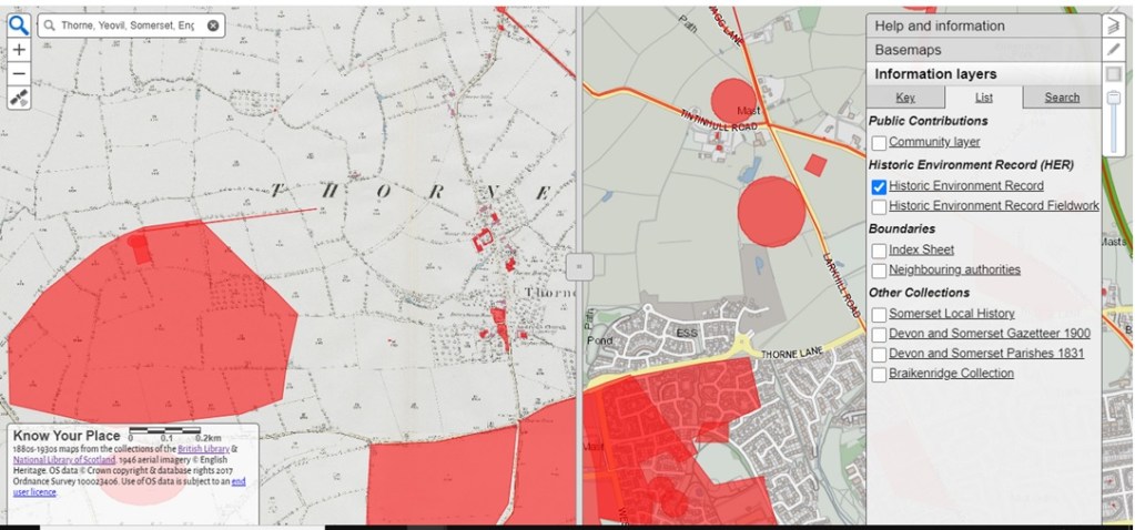
  • Historic Environment Record (HER)
    • Historic Environment Record
    • Historic Environment Record Fieldwork
  • Boundaries
    • Index Sheet
    • Neighbouring authorities
  • Other Collections
    • Somerset Local History
    • Devon and Somerset Gazetteer 1900
    • Devon and Somerset Parishes 1831
    • Braikenridge Collection
Know Your Place-a resource review_Shersca Genealogy_Map view of Thorne, Yeovil, Somerset_view with HER positioning
A view of the Know Your Place- Somerset base map and comparison map, showing the Information Layers toolbar with the Historic Environment Record view. Courtesy of © Know Your Place- West of England.

Remember that these may be slightly different for different counties, but you can click on each heading for more information. Although at time of writing (December 2020) this facility does not seem to be working as it should.

What information do they contain?

As it suggests, the Community Layer contains contributions made by the people and organisations outside of those working on the Know Your Place project. This layer can contain pictures or paintings of places or even of monuments, people and coats of arms.

The Historic Environment Record layer is particularly useful, as it plots out the locations which have been researched on the map. These are not just Roman settlements and other ancient features, but could also be listed buildings or even WW2 defences and troop camps. For my own street, this layer shows the location of WW2 air raid shelters, emergency water tanks and roadblocks. These entries (for Somerset at least), then have links to external HER sites which in turn give you more information.

For Somerset, the Gazetteer and Parishes layers can show you where certain places from that specific gazetteer were located and also the parish boundaries. Again, very useful to be able to ‘see’ things which are only described elsewhere.

You can take these layers off or turn them on again by clicking the box next to them on the Information layers tab. This can be found in the toolbar on the right hand side of the screen, below the Basemaps tab. Again, have a look at what is available for the place you are looking for. There might be different layers to choose from.

Exploring the maps will certainly give you plenty to do, especially if you are at a loose end over the festive period. But the website still has more to offer. From the homepage, you can access other tabs which contain information about the project, a blog, a learning pack (aimed at Key Stages 2-4) and information about their online exhibition.

Caveats

There are a few caveats about using the website, chiefly the coverage of the maps offered need to be checked, both in terms of time period and geographical area. The other big issue is that this will only help those people with ancestors in or with a connection to the West of England. If you are hoping or planning to use images of the maps you find or any of the information included (for example, in paid research work or in a publishing capacity), do have a look at the ‘Copyright Guidance’ section. Most of the maps used are already being used on the website with the permission of a third party, so you may well have to contact that third party for any permissions you need. That being said, I would certainly recommended having a look at Know Your Place. Who knows, perhaps this could one day be expanded to other areas of the UK?

As this is also the last blog post of 2020, have a very Merry Christmas and let’s hope for a better year next year!

© 2020 Shersca Genealogy.


[1] Know Your Place- West of England. About the Project. http://www.kypwest.org.uk/about-the-project/ : accessed 18 December 2020.
Friday, December 4, 2020

A House History from Yeovil: Part 3

 Welcome to the last post in my series about the history of my own house in Yeovil. So far, we have travelled back through time to the 1930s when a solicitor’s accountant (Barton Wey) lived in my house. Then we visited Albert Bollen who owned the land the house was later built on for a brief period in 1894, before his death a year later. A Yeovil man, he rose from a labouring background to becoming a solicitor himself. This time, we meet the men who were involved with the same land in the 1840s; the owner and the tenant.

Wonderful tithes...

The beginning of this story is not a baptism or birth, but a map. The 1848 Tithe Map for Preston Plucknett to be precise. Before Yeovil grew to its current size, there were many small villages on its western outskirts. Places like Thorn, Brympton, Lufton and of course Preston (or Preston Plucknett), were villages in their own right. Now of course, these villages are slowly being consumed by Yeovil as it expands ever closer to the larger villages of Odcombe and Montacute. This link to Google Maps will give you some idea of the area today.

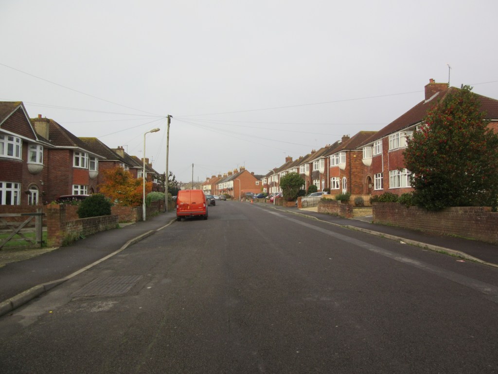
Back in the 1840s however, Preston was its own separate village. Its history is too great to go into in this post, but local historian Bob Osborn has some excellent information here. The 1848 Tithe Map (found at KnowYourPlace-Somerset), shows that my house was in fact a field at that time. It was part of plot 137 and you can see the track that would later become Preston Grove. The accompanying apportionment[1] contains a wealth of detail. It tells us that the owner of plot 137 was one Robert Tucker and the occupier was one Joseph Roberts. The two men were also owner and occupier of plots 132-134, 136-139 and 141-148. Plot 135 was owned by Robert Tucker but occupied by one Gouly de Chaville. More about him another time!

These plots of land occupied by Joseph Roberts made up a total of 105 acres, 2 rods and 5 perches. Not a bad size and worth £5 5 shillings and 6 pence to the local vicar. For more information on how tithes worked, see my previous blog post on the subject. Altogether, this land was farming land and a part of Preston Lower Farm. The majority was pasture and meadow land, with plot 137 named as ‘Second Close’- this was also pasture. An additional aspect I would like to research in future is whether this was land for sheep or cattle.

A House History from Yeovil, Part 3_Shersca Genealogy_Current view of Tithe plot 137, Preston Plucknett
A current view of Tithe Plot 137. Once a field, this is now a residential street considered to be a part of Yeovil. © 2020 Shersca Genealogy.

Who were the people?

Robert Tucker

So the tithe map has told us who owned and occupied the land, but what more is there to know? As you might imagine, the owner Robert Tucker was quite a well to do gentleman in Yeovil. Both he and his father (another Robert Tucker!) appear in the Somerset Electoral Register of 1832 for Yeovil Parish. They both lived in Hendford (another part of Yeovil) and both held a freehold house each, Robert senior in Milford and Robert junior in Hendford. This was what qualified them to be able to vote.[2] Robert senior died on 16 October 1841 (in Yeovil) at the age of 75. He was a ‘gentleman’ according to his death certificate.[3] Robert junior died 26 years later on 27 October 1867, at Hendford in Yeovil. He was 65 and a ‘landed proprietor.’[4] This certainly has airs and graces, but describes him quite accurately!

From what I have discovered, Robert junior was one of the many Yeovil glove manufacturers. He contributed to his community as Churchwarden, Town Commissioner and later Mayor of Yeovil (1858-1860). You can find this information and much, much more on Bob Osborn’s Yeovil website.

Joseph Roberts

But what about Joseph Roberts? There is certainly no handy biography of him to be found. But it turns out that Joseph was another man who elevated himself above his initial station in life.

Joseph was born to James and Jane Roberts in Marston Magna, Somerset. His baptism took place on 29 May 1806 in Marston.[5] Joseph’s obituary states that he began his business life at the ‘early’ age of 18 and was connected for many years with his brother-in-law George Hart. George was a well-known auctioneer and valuer in Yeovil and Martock.[6] The marriage of Joseph and George’s sister Mary took place on Christmas Eve of 1829 at Martock parish church. George was in fact, one of the witnesses.[7]

The move to Preston

A mere two years later in 1831, Joseph and wife Mary moved to Preston Plucknett and occupied Preston Lower Farm. According to the obituary, Joseph also farmed a large holding in Tisbury at the same time (on the Pyt House Estate).[8] This may explain why Joseph had moved from Preston to West Tisbury by the time of the 1861 Census. The rest of his family moved with him and they may have moved as early as 1855. Joseph was included in Kelly’s Directory for Wiltshire as being a farmer of West Tisbury for that year.[9]

Before the move though, Joseph and Mary farmed Preston Lower Farm for about twenty years, whilst their family steadily grew. From the various census records found,[10] [11] Joseph and Mary had nine children during their time together: Jane, James, George, John, Francis, Joseph, William, Thomas, William and Mary Anna. Following up with all of these children is a project for another day!

By the time of the 1851 Census,[12] Joseph was employing seven labourers on Preston farm. After the move to Tisbury and Pythouse farm,[13] the size of Joseph’s farming land increased significantly to 440 acres. I am not surprised that Joseph needed to employ ten labourers and three boys to help him work the land! The most important piece of information on the 1861 Census though, is that Joseph is now calling himself a ‘landed proprietor’ as well. This certainly signals a rise in status, but the size of the farm also tells us that he had the funds for a holding that large. Even if it was rented, he must have had the means to pay that rent.

A rise in social status

But Joseph did not stop there. By the time of the 1871 Census,[14] not only had the family moved again, but Joseph was reporting a further change of occupation. The family were living at Jackley House in the village of Wyke, near Axminster in Devon (in Dorset at the time). From the looks of things, son William (to be determined which William!) was farming 200 acres and employing five men and two boys to help. His father Joseph was calling himself a ‘surveyor and landowner,’ which suggests that he had made the move from farming and renting land (as he had Preston Lower Farm from Robert Tucker) to owning land that others farmed.

This is borne out by various newspaper appearances that Joseph makes in his later years. In 1878, Joseph was named an umpire for a dispute over farming land,[15] a referee for a similar case in 1886[16] and a named evaluator of farming land in another similar case of 1887.[17] The latter article calls Joseph ‘a land surveyor of over 50 years’ experience.’ It is probably not surprising to learn that his obituary mentions that he valued land in 14 counties and a high value was placed upon his judgment in the matter of land surveying. Perhaps the early contact with his brother-in-law paved the way for Joseph in the world of land surveying.

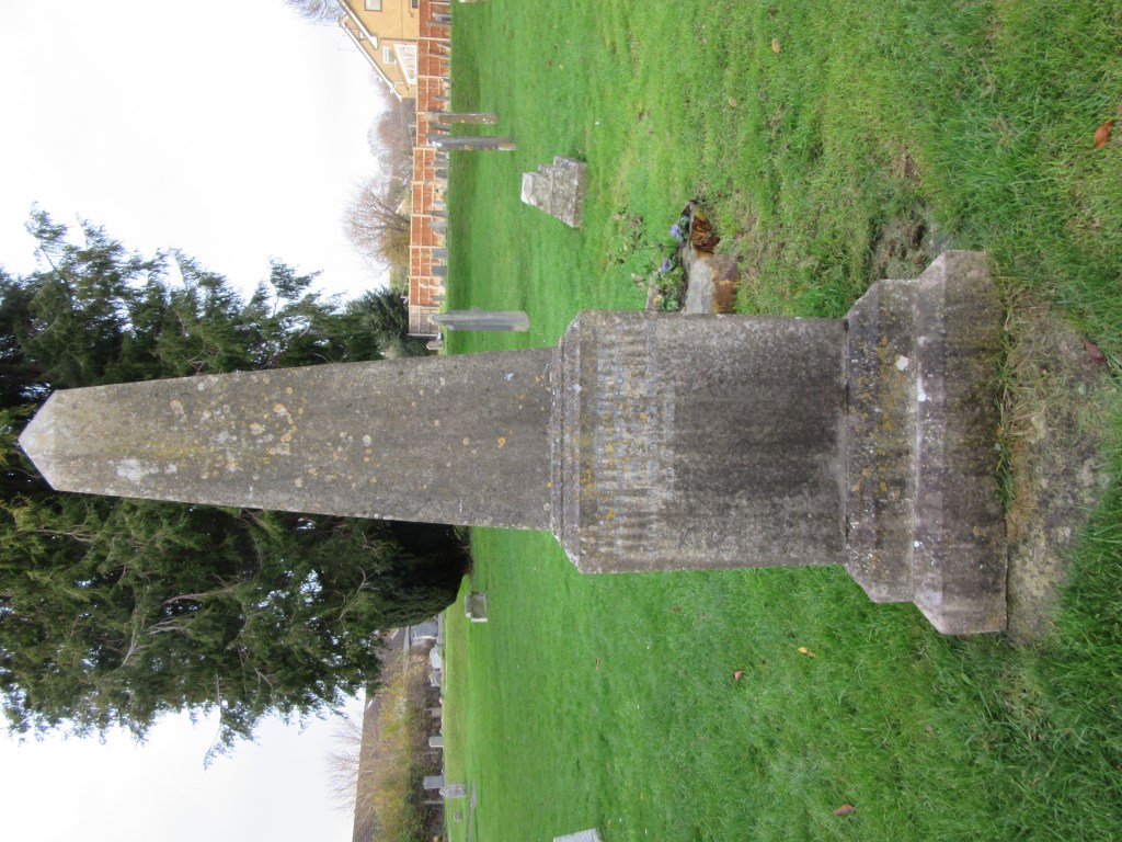
A House History from Yeovil, Part 3_Shersca Genealogy_Memorial for Joseph Roberts in St. James' Churchyard, Preston Plucknett
The monument for Joseph Roberts, his wife Mary, son George and grandson Harold. Located in the churchyard of St. James' Church, Preston Plucknett. © 2020 Shersca Genealogy.

A return to Preston

From 1872, Joseph moved back to Preston where he apparently ‘carried on the business of an estate agent and auctioneer.’ His son William was involved too for a time. Joseph also founded the company Roberts, Son & Tory.[18] This company is certainly something that warrants further research. Sadly, Joseph’s wife Mary died on 09 March 1877 of bronchitis.[19] According to her death certificate, Mary was 73.

Mary's age is rather interesting though, as she died twenty years before her husband. Looking for a baptism of a Mary Hart in about 1804 in her birthplace of Martock, returns a curious result. The only baptism in the right place and at the right time was for a girl named Mary Hart who was aged 10 years old when she was baptised on 29 May 1805.[20] Her parents were Joseph and Sarah Hart and Mary was baptised with her siblings Ann (aged 16), Thomas (aged 13) and Avis. If this is correct, then Joseph’s wife Mary was a good ten years older than her husband and ten years older than every age she gave on every record found! This deserves some further research, but if correct, Mary must have looked amazing for her age!

For most of the rest of Joseph’s life, he lived in Preston Plucknett,[21] [22] although not at Preston Lower Farm again. This time around, he could afford to live in a ‘private house’ (the exact address is not clear). He could also continue to pay to be included in the local directories. For both the 1889[23] and 1895[24] editions, he can be found under the list of private residents of Preston Plucknett. At some point before his death, Joseph moved back to Marston Magna, to live with his son William, at Marston Court. Joseph’s obituary records that he had apparently always wanted to end his life in the place it began. Joseph Roberts died at Marston Court on 28 March 1897 at the grand old age of 90.[25]

An impressive monument

One further wonderful discovery made during the research for this post (of which there is much more to perform), is that Joseph was buried in St. James’ Church in Preston Plucknett and has a rather impressive obelisk shaped memorial![26] This memorial also marks his wife Mary (supposedly born on 14 April 1804), their son George and their grandson Harold (a son of William Roberts). If that is not a mark of elevated status, I do not know what is!

A House History from Yeovil, Part 3_Shersca Genealogy_Memorial for Joseph Roberts in St. James' Churchyard, Preston Plucknett_close up
A close up view of one side of Joseph's memorial, showing Joseph, his wife Mary and their son George. © 2020 Shersca Genealogy.

And finally...

We have finally reached the end of the journey into the history of my house, at least as far as this blog is concerned. There are many more stories that did not make the final posts and much more to discover besides. I have thoroughly enjoyed discovering Barton Wey, Albert Bollen and Robert Tucker and Joseph Roberts. I hope you have enjoyed their stories as much as I have!

© 2020 Shersca Genealogy.


[1] Tithe apportionments. England. Preston Plucknett, Somerset. 1848. TUCKER, Robert (Owner) and ROBERTS, Joseph (Occupier). Plan number: 137. Collection: Diocese of Bath and Wells; Tithe Maps and appotionments; Tithe appotionments. D/D/rt/A/475. Somerset Heritage Centre, Taunton, Somerset, England.

[2] Electoral listings. England. Yeovil Parish, Stone Hundred, Somerset. 1832. TUCKER, Robert, the younger and TUCKER, Robert, the elder. Nos. 5498-5499. p. 120. In: Raymonds Electoral Registers (1996) The Somerset Electoral Register Western Division 1832. Exeter: S. A. & M. J. Raymond.

[3] Deaths (CR) England. Yeovil, Somerset. 16 October 1841. TUCKER, Robert. Entry no. 313.

[4] Deaths (CR) England. Yeovil, Somerset. 27 October 1867. TUCKER, Robert. Entry no. 374.

[5] Baptisms (PR) England. Marston Magna, Somerset. 29 May 1806. ROBERTS, Joseph. Collection: Somerset, England, Church of England Baptisms, Marriages, and Burials, 1531-1812. http://www.ancestry.co.uk : accessed 26 November 2020.

[6] Obituaries. (1897) Western Gazette.02 April. ROBERTS, Joseph. p. 6c. Collection: British Newspapers, 1710-1965. www.findmypast.co.uk : accessed 26 November 2020.

[7] Marriages (PR) England. Martock, Somerset. 29 May 1806. ROBERTS, Joseph. Collection: Somerset, England, Church of England Baptisms, Marriages, and Burials, 1531-1812. http://www.ancestry.co.uk : accessed 26 November 2020.

[8] Obituaries. (1897) Western Gazette.02 April. ROBERTS, Joseph. p. 6c. Collection: British Newspapers, 1710-1965. www.findmypast.co.uk : accessed 26 November 2020.

[9] Directories. England. (1855) Post Office Directory of Hampshire, Wiltshire & Dorsetshire. London: Kelly & Co. p. 119 [464]. Collection: UK, City and County Directories, 1766 – 1946. www.ancestry.co.uk : accessed 26 November 2020.

[10] Census records. England. Preston Plucknett, Somerset. 06 June 1841. ROBERTS, Joseph [head]. PN: HO107/958. FL 4. BN 7. ED 10. p. 2. http://www.ancestry.co.uk : accessed 26 November 2020.

[11] Census records. England. Preston [Plucknett], Somerset. 30 March 1851. ROBERTS, Joseph (head). PN: HO107/1930. FL 233. SN 61. ED 4. p. 14. http://www.ancestry.co.uk : accessed 26 November 2020.

[12] Ibid.

[13] Census records. England. West Tisbury, Tisbury, Wiltshire. 07 April 1861. ROBERTS, Joseph (head). PN: RG9/1321. FL 58. SN 166. ED 3. p. 27. http://www.ancestry.co.uk : accessed 26 November 2020.

[14] Census records. England. Axminster, Dorset [Devon]. 02 April 1871. ROBERTS, Joseph (head). PN: RG10/2033. FL 37. SN 2. ED 2. p. 1. http://www.ancestry.co.uk : accessed 26 November 2020.

[15] Southern Times and Dorset County Herald. (1878) In the Court of the Queen’s Bench on Wednesday last…[Emas Shutler v. Alexander Osborne]. Southern Times and Dorset County Herald. 29 June. p. 5c. Collection: British Newspapers, 1710-1965. www.findmypast.co.uk : accessed 26 November 2020.

[16] Shepton Mallet Journal. (1886) Important case under the Agricultural Holdings Act. Shepton Mallet Journal. 16 July. p. 5d. Collection: British Newspapers, 1710-1965. www.findmypast.co.uk : accessed 26 November 2020.

[17] Western Times. (1887) A Farmer’s Appeal against Rates; Important decision. Western Times. 29 January. p. 3e. Collection: British Newspapers, 1710-1965. www.findmypast.co.uk : accessed 26 November 2020.

[18] Obituaries. (1897) Western Gazette.02 April. ROBERTS, Joseph. p. 6c. Collection: British Newspapers, 1710-1965. www.findmypast.co.uk : accessed 26 November 2020.

[19] Deaths (CR) England. Preston [Plucknett], Somerset. 09 March 1877. ROBERTS, Mary. Entry no. 27.

[20] Baptisms (PR) England. Martock, Somerset. 29 May 1805. HART, Mary. Collection: Somerset, England, Church of England Baptisms, Marriages, and Burials, 1531-1812. http://www.ancestry.co.uk : accessed 26 November 2020.

[21] Census records. England. Preston Plucknett, Somerset. 03 April 1881. ROBERTS, Joseph (head). PN: RG11/2393. FL 102. SN 13. ED 10. p. 17. http://www.ancestry.co.uk : accessed 26 November 2020.

[22] Census records. England. Preston Plucknett, Somerset. 05 April 1891. ROBERTS, Joseph (head). PN: RG12/1899. FL 114. SN 54. ED 11. p. 10. http://www.ancestry.co.uk : accessed 26 November 2020.

[23] Directories. England. (1889) Kelly’s Directory of Somersetshire. London: Kelly & Co. p. 314 [346]. Collection: UK, City and County Directories, 1766 – 1946. www.ancestry.co.uk : accessed 26 November 2020.

[24] Directories. England. (1895) Kelly’s Directory of Somersetshire, Gloucestershire and the City of Bristol. London: Kelly & Co. Limited. p. 352 [370]. Collection: UK, City and County Directories, 1766 – 1946. www.ancestry.co.uk : accessed 26 November 2020.

[25] Deaths (CR) England. Marston Magna, Somerset. 28 March 1897. ROBERTS, Joseph. Entry no. 488.

[26] Monumental Inscriptions. England. St. James’ Church, Preston Plucknett, Yeovil, Somerset. ROBERTS family. Transcribed by Rhiannon Lloyd, 29 November 2020.